Photomonitoring™ is a low-cost monitoring solution based on the analysis of images acquired by different sensors and platforms (e.g. smartphones, fixed cameras, UAV, airplanes, satellites) at different times thanks to Advanced Digital Image Processing techniques developed by NHAZCA.
flexibility
Multiple sensors and platforms
Photomonitoring™ is featured by a high flexibility thanks to the possibility to use data coming from different sensors and platforms as input data allowing sub-pixel accuracy in displacements monitoring.
Smartphones
fixed cameras
drones
airplanes
satellites
Risk Management
Risk Management
Photomonitoring™ supports landslide risk management. In particular, NHAZCA is currently working together with Sapienza – University of Rome on challenging solutions for rockfalls early detection, also based on precursors analysis.
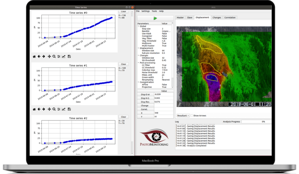
Photomonitoring™ is based on a set of advanced image processing algorithms (e.g. digital image correlation and change detection) implemented in the IRIS software developed by NHAZCA to enable this technology for automatic monitoring applications also in complex outdoor environments.
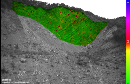
A SUCCESSFUL EXAMPLE
Photomonitoring™ results on the Ruinon complex landslide (Italy) recorded by a standard HD webcam.
Hermle, D., Gaeta, M., Keuschnig, M., Mazzanti, P., and Krautblatter, M.: Multi-temporal analysis of optical remote sensing for time-series displacement of gravitational mass movements, Sattelkar, Obersulzbach Valley, Austria, EGU General Assembly 2021, online, 19–30 Apr 2021, EGU21-8011, https://doi.org/10.5194/egusphere-egu21-8011, 2021 www.nhazca.it/wp-content/uploads/2022/02/remotesensing-14-00455-v4.pdf
REAL-TIME ACQUISITION
Early warning
Photomonitoring™ represent an ideal technique for landslide monitoring where processes need to be analysed with different acquisition frequencies (e.g. low, near real-time, real time) according to their dynamic behaviour.
Near real-time and real-time acquisition frequencies allow an early warning approach, that is fundamental for critical sites and infrastructure management.
NHAZCA(Natural HAZards Control and Assessment), Startup Company of “Sapienza” University of Rome, is an international leader in the analysis and monitoring of natural hazards and large infrastructures for the management and mitigation of risks.
NHAZCA is strongly characterized by a highly integrated and motivated team which contributes to its success and growth over time. Our team consists of enthusiasts geologists, engineers, project managers, and technicians coming both from private and academic world, also benefiting from a world-class network. Since our foundation, our team has been growing extensively and our ambition is to continue to develop new solutions and services while expanding our geographic footprint. Each co-worker is a specialist in his or her field.
")