Investigation of post-fire instability processes by burned area mapping and geomorphological analysis
Issue
To achieve, through specialized studies, an appropriate understanding of the instability processes occurred in the study area following large fires, investigating the main predisposing and triggering factors.
Solution
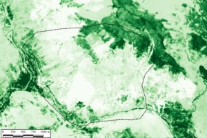
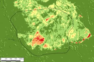
A study through the processing, post-processing and interpretation of multispectral images from satellite platform (Sentinel, ESA) was carried out. PhotoMonitoring techniques using specific algorithms were used allowing to identify significant changes (pre/post fires) within the study area. In detail, the NDVI (Normalized Different Vegetation Index) was used to assess the state of the forests and the NBR (Normalized Burn Ratio) to map the severity of the burned areas, in order to estimate the extent of damage caused by fires. In addition, the analysis included the use of additional geological data and information collected during field surveys as well as thematic databases.