
Convergence Monitoring – Casacastalda Tunnel
Issue
Excavation through varicolored clays required close convergence monitoring. Conventional topography was used as the reference method but provided only sparse, point-based and discontinuous data dependent on manual operations. A complementary solution was needed to add continuous, full-field, and automated coverage.
Solution
NHAZCA provided Photomonitoring™ as a proof of concept service. Two high-resolution cameras acquired images at short intervals. IRIS software updated reference images at each excavation step, generating full-field convergence maps of the tunnel cross-section in near real time.
Achievements
Photomonitoring™ delivered a continuous stream of convergence data that complemented topography. It enabled earlier recognition of deformation trends, created a photographic archive of excavation phases, and reduced manual interventions in hazardous areas, confirming its potential as a future standard service for underground monitoring.
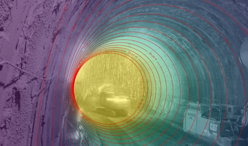
Depth map of the tunnel reconstructed using proprietary IRIS software
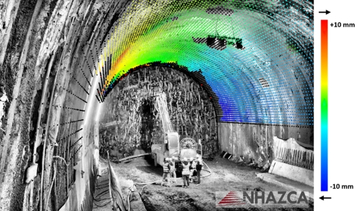
Example of a full-field displacement map of the tunnel section monitored by Photomonitoring technology